





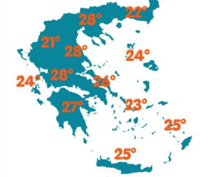
Today marks the end of a long period of increased instability, according to the forecast by meteorologist Giorgos Tsatrafyllias from protothema.gr.
From next week, the weather will improve significantly both on land and at sea, with temperatures gradually rising. In fact, the Holy Spirit long weekend is expected to bring good weather for those planning trips.
More specifically:
For today, Monday May 25, mainly during the midday and afternoon hours, rain and scattered thunderstorms are expected over mainland Greece and Crete. In some areas, the phenomena will be temporarily more intense in the Peloponnese, western Central Greece, Epirus, Thessaly, and Central Macedonia.
Maximum temperatures will reach 27–28°C in western and northern areas and around 26°C in the Ionian, Crete, and the Dodecanese. Winds in the Ionian will be weak, while in the Aegean they will blow from the north-northwest at up to 6 Beaufort.
In Athens, after midday there is a chance of light rain, mainly in the northern parts of the region. Winds will be northerly up to 6 Beaufort, and temperatures will range between 17 and 27°C.
In Thessaloniki, there will be intermittent rain until the afternoon. Winds will be almost calm over the Thermaic Gulf, and temperatures will reach up to 28°C.
Temperature on a further upward trend
On Tuesday and Wednesday, instability will be more limited and will mainly affect central and northern Greece.
On Thursday and Friday, it will temporarily increase over mainland areas, with local showers and thunderstorms. Temperatures will gradually rise and locally reach 32–33°C.
For the Holy Spirit long weekend, the latest forecasts indicate very good weather both on land and at sea, with temperatures around 30°C.
Ask me anything
Explore related questions




