
The Special Weather Advisory issued yesterday is updated according to the latest forecast data.
Cold and unstable air masses in the upper atmosphere will remain over our country until Saturday (31-08-24) affecting in places most of the mainland with heavy rain and thunderstorms, accompanied by a high frequency of lightning and local hailstorms. Occasionally, the phenomena will be accompanied by very strong winds (bourines).
In detail, locally heavy rain and thunderstorms are forecast:
A. Today Friday (30-08-24)
From noon until the evening hours in central Macedonia (mainly in Halkidiki), eastern Macedonia, Peloponnese, Central Greece (mainly in the central and eastern parts, including Attica), Epirus, Thessaly, Evia and possibly the Sporades.
Β. Tomorrow Saturday (31-08-24)
From the morning hours in Thessaly, Sporades, Evia.
During the midday and afternoon hours in the Peloponnese, Sterea (including Attica) and possibly in some places in Epirus and Macedonia.
Almost 20,000 lightning strikes and locally strong phenomena on day 1 of instability
Strong electrical activity and strong in places phenomena were the main features of the 1st day of instability of weather in the country.
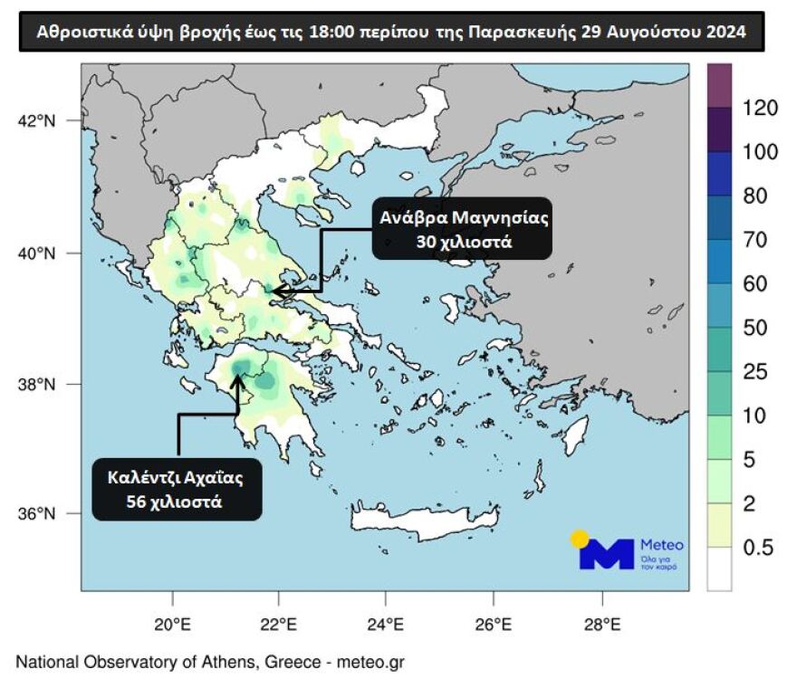
According to the recordings of the network of automatic meteorological stations of meteo.gr / National Observatory of Athens, the highest cumulative precipitation height up to about 18:00 on Thursday 29/08 was recorded in Kalenji, Achaia and is equal to 56 mm. Characteristic of the strength of the phenomena is that 38.4 mm fell in just 30 minutes of the hour. Map 1 shows the distribution of the cumulative rainfall according to the network stations and the 2 highest rainfall heights are marked.
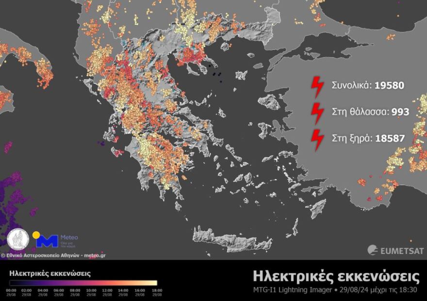
The electrical activity in the atmosphere was recorded by the Lightning Imager on the MTG-I1 satellite. Map 2 shows the electrical discharges recorded from the beginning of the 24-hour period until 15:30 UTC (18:30 GMT). As can be seen from this, 19,580 discharges were recorded, 18,587 of which were over dry land and 933 over sea.
Trees have fallen from the powerful storm that swept through Thessaloniki
The storm that started late yesterday afternoon caused problems in Thessaloniki. The fire brigade received calls about falling trees on the road – mainly in the area of Lagada, but also in areas of Thessaloniki. Heavy rainfall occurred in the west of the urban complex and in the northwest of the prefecture.
Watch video and photos:


The weather today
At first, local rain and occasional thunderstorms are expected, mainly in the eastern parts of Thessaly and Halkidiki. Gradually the phenomena will extend to the rest of the mainland, the Ionian Sea, the North Aegean and Crete and will intensify. There is a possibility of hail mainly for the mountainous continental areas. Dust concentrations in the atmosphere will be relatively increased.
The temperature in Western Macedonia will range from 17 to 29 degrees Celsius, in the rest of Macedonia and Thrace from 21 to 32, in Thessaly from 22 to 34, in Epirus and Western Central Greece from 19 to 32, in the rest of Central Greece from 20 to 33, in the Peloponnese from 17 to 33, in the Ionian islands from 22 to 33, in the North and East Aegean islands from 20 to 33, in the Cyclades and the Dodecanese from 19 to 32 and in Crete from 18 to 33 degrees Celsius.
The winds in the North Aegean will blow from the north from 2 to 4 Beaufort. In the Central Aegean the winds will initially blow from variable directions up to 3 Beaufort but from midday they will become northerly 2 to 4 Beaufort. In the South Aegean, winds will blow from westerly directions 3 to 5 Beaufort. In the Ionian Sea the winds will blow from northwestern directions 2 to 4 Beaufort.
SATURDAY 31-08-2024
In Thessaly, the Sporades and Evia, unstable weather with showers and thunderstorms, heavy in places, accompanied by a high frequency of lightning and local hailstorms and improvement in the evening.
In the rest of the country the weather will initially be almost clear, with a few local clouds in central and eastern Macedonia, Thrace, Sterea and the Ionian Sea. Weak local showers will occur in the morning hours in Central Greece and possibly in the Ionian Sea. From the midday hours clouds will increase in the mainland and Crete where local rain or rain will occur, while in the mainland there will be sporadic thunderstorms. In Central Greece (including Attica), the Peloponnese and possibly in some places in Epirus and Macedonia the phenomena will be strong in places.
An improvement is expected in the evening hours.
Winds will blow from the north 3 to 4 and in the Aegean Sea 4 to 5, locally 6 Beaufort. In the areas where strong phenomena will occur, the winds will be very strong in places (bourines).
The temperature will drop slightly and will reach 30 to 32 degrees Celsius in the mainland, the Ionian Sea, the Dodecanese and Crete and 27 to 28 degrees Celsius in the rest of the island country.
SUNDAY 01-09-2024
Initially unsettled weather with showers and occasional thunderstorms in the Sporades, Evia, and the eastern parts of Thessaly with gradual improvement. In the morning hours there will be clouds in the southern Ionian Sea, southern Peloponnese, Cyclades and Crete, with local rain showers.
In the rest of the country the weather will be initially almost clear with local clouds in central and eastern Macedonia and Thrace, but in the midday – afternoon hours clouds will increase in the mainland, where local rain or rain and occasional thunderstorms will occur, mainly in the central and southern parts.
Improvement is expected from the evening hours.
Winds will blow from the north at 3 to 4 Beaufort, and in the Aegean Sea 4 to 5, locally 6 Beaufort.
The temperature will rise slightly in the west and north and will reach 30 to 32 and locally 33 degrees Celsius in the mainland, the Ionian Sea, the Dodecanese and Crete and 27 to 29 degrees Celsius in the rest of the island country.
MONDAY 02-09-2024
Initially generally clear weather throughout the country with local clouds in central and eastern Macedonia, Thrace, southern Ionian, Evia and the Cyclades (mainly the western parts).
In the midday – afternoon hours clouds will increase in the mainland and Crete, where local rain or rain will occur and in the mainland isolated thunderstorms will occur.
Improvement is expected in the evening hours.
Winds will be variable 3 to 4, in the south from westerly directions 3 to 4 and in the southeast locally up to 5 Beaufort.
The temperature will rise slightly further.
Ask me anything
Explore related questions


