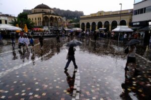
Light showers and thunderstorms occurred across much of the country on Thursday (4/24) with emphasis on the mainland and Crete.
Analysis of data from the third-generation European weather satellite Meteosat-12 and its Lightning Imager (LI) instrument showed that more than 6,000 electrical discharges had been recorded by 17:40 on Thursday.
According to the network of automatic weather stations of the National Observatory of Athens / meteo.gr, until 17:30 on Thursday, the highest rainfall was recorded at the weather station in Isoma Kilkis and was equal to 33.4 mm, while locally significant rainfall was also recorded in Attica, with the highest rainfall recorded at the weather station in SKA with 26.6 mm.
As Kostas Lagovardos, director of research at the Athens Observatory, told protothema.gr, earlier, the instability of the weather will continue both tomorrow and Saturday.
In fact, as he points out, tomorrow the phenomenon will extend beyond the mainland to the island country. However, a drop in temperature to normal seasonal levels is expected from early next week, as northerly winds are expected. “Instability is normal for the season, high temperatures are not,” Lagovardos noted.
A Breakdown of the Weather on Friday, According to the National Weather Service
General Overview:
Cloudy with periods of partial cloudiness, local rain, and occasional thunderstorms initially in the western parts of the country and on the central mainland. From midday onwards, these conditions will spread to the rest of the mainland, Evia, the Cyclades, Crete, and the Dodecanese. Thunderstorms in some areas of the central continent may be accompanied by hail at times. By nightfall, the phenomena will subside in most regions.
Winds: Variable, 3 to 4 Beaufort, becoming southwesterly at up to 5 Beaufort.
Temperature: Little change expected, reaching 20 to 22 degrees Celsius in most areas.
Regional Forecasts
Macedonia, Thrace:
- Weather: A few clouds becoming more prevalent by midday and afternoon, with local showers and occasional thunderstorms.
- Winds: Variable, 2 to 4 Beaufort.
- Temperature: Ranges from 10 to 22 degrees Celsius. In western Macedonia, it will be 3 to 4 degrees lower.
Ionian Islands, Epirus, Western Greece, Western Peloponnese:
- Weather: Sporadic thunderstorms, mainly affecting the mainland during midday and afternoon.
- Winds: West-northwest at 3 to 4 Beaufort, increasing to up to 5 Beaufort in the evening in the south.
- Temperature: Between 12 to 21 degrees Celsius, with the interior of Epirus seeing a minimum of 3 to 4 degrees lower.
Eastern Sterea, Evia, Eastern Peloponnese:
- Weather: Strong phenomena likely early in the morning until the afternoon, tapering off by evening. In the eastern Peloponnese, expect a few clouds and local rain until the afternoon, with sporadic thunderstorms developing later.
- Winds: Variable, 3 to 4 Beaufort, with southwestern winds up to 5 Beaufort.
- Temperature: Ranging from 12 to 22 degrees Celsius.
Crete:
- Weather: Thunderstorms predicted.
- Winds: From westerly directions, easing from 3 to 5 Beaufort, with local gusts up to 6 Beaufort in the morning in the south.
- Temperature: Between 14 to 22 degrees Celsius.
Nisi of Eastern Aegean – Dodecanese:
- Weather: Expect intense phenomena in the Dodecanese in the afternoon; however, these will stop in the Eastern Aegean islands.
- Winds: Northwest 3 to 4 Beaufort in the north, southwest 3 to 5 Beaufort in the south.
- Temperature: From 15 to 22 degrees Celsius.
Thessaly:
- Weather: Severe weather conditions, likely strong in eastern Thessaly from the early morning until the afternoon, easing by early evening.
- Winds: Variable, 3 to 4 Beaufort.
- Temperature: Ranges from 11 to 22 degrees Celsius.
Attica:
- Weather: Few clouds in the evening.
- Winds: Variable, 3 to 4 Beaufort.
- Temperature: From 13 to 21 degrees Celsius.
Thessaloniki:
- Weather: General conditions similar to Attica.
- Winds: Variable, 3 to 4 Beaufort.
- Temperature: From 12 to 22 degrees Celsius.
Heraklion: Heavy Rain and Hail Hit Many Areas of the Prefecture
Severe weather impacted Crete on Thursday, particularly in the Heraklion prefecture, where heavy rainfall and hail were reported in various areas.
As reported by neakriti.gr, the weather deteriorated rapidly in the Messara area of the Minoa Pedias municipality and other regions, with thick hail falling during the midday hours.
One citizen reported to the media that outside Agia Varvara towards Heraklion, the rainfall was so intense that drivers had to pull over, as the water was flowing rapidly, and stones were falling onto the road.
Heavy hail was also noted in the municipality of Argithea in the Karditsa region.
Ask me anything
Explore related questions


