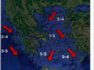
The week begins with strong meltemi winds across the Aegean Sea, reaching up to 7 Beaufort in some areas. Scattered showers are possible over mountainous regions of the mainland, particularly during the midday and afternoon hours. Temperatures are not expected to change significantly in the coming days. These strong northerly winds will persist through Wednesday and begin to weaken from Thursday onward.
Very High Fire Danger in Four Regions
According to the Fire Risk Forecast Map issued by the General Secretariat for Civil Protection, a very high fire danger (risk category 4) is forecast for Monday in several parts of the country. The regions at very high risk include Heraklion, Lassithi, Samos, and Ikaria. Additionally, several other regions are under a high fire risk warning (risk category 3), including southern Evia, Chania, Rethymno, the Dodecanese, the Cyclades, Lesvos, Chios, and Psara. These alerts reflect dry conditions and strong winds, which increase the likelihood of wildfire outbreaks.
July 2025 Long-Term Temperature Forecast: Warmer Than Average
Long-range forecasts issued in June suggest that July 2025 will likely be warmer than usual across Southeastern Europe, including Greece. Based on 400 climate model scenarios, 93 percent indicate that the monthly average temperature will exceed the seasonal norm (based on the 1993–2016 reference period). There is a 42 percent chance of a temperature deviation between +0 and +1°C, a 41 percent chance for a deviation between +1 and +2°C, and a 10 percent likelihood of a deviation exceeding +2°C. Only 7 percent of scenarios suggest a slight cooling.
The average of all scenarios predicts a temperature increase of approximately +1.04°C for the region. These forecasts are derived from eight international climate centers, including ECMWF (Europe), UKMO (United Kingdom), Meteo-France (France), JMA (Japan), NCEP (United States), DWD (Germany), CMCC (Italy), and BOM (Australia), coordinated by the European Commission’s Copernicus Climate Change Service. It is important to note that while these forecasts help identify seasonal trends, they come with a degree of uncertainty and should not be interpreted as precise daily predictions.
Forecast Accuracy Review: May 2025
In May 2025, Southeastern Europe experienced a slightly cooler month than anticipated. The average temperature deviation was –0.20°C, while the forecast issued in April had projected a +1.03°C deviation. This outcome corresponded to the fourth most probable forecast range, with a 14 percent likelihood. This discrepancy highlights the limitations and variability of long-term forecasts, especially in months with transitional or unsettled weather patterns.
Daily Weather Summary
Monday, June 16:
The weather will be generally clear, with localized showers and thunderstorms expected in mountainous areas during midday and afternoon hours. Northern winds in the Aegean will blow at intensities of 6 to 7 Beaufort, while the Ionian Sea will experience lighter northwest winds of 3 to 4 Beaufort. Temperatures will range from 12 to 33 degrees Celsius, varying by region. Athens will see clear conditions with temperatures from 23 to 31°C, while Thessaloniki will experience similar conditions with highs around 30°C.
Tuesday, June 17:
Clear skies are expected for most areas. In the western and northern mainland, some clouds will form in the afternoon, bringing light rain and isolated thunderstorms in mountainous areas. Winds will remain strong in the Aegean at 6 to 7 Beaufort from the north, while the Ionian will see lighter, variable winds. Temperatures will rise slightly, with highs reaching up to 34°C in parts of the mainland and the Ionian region.
Wednesday, June 18:
Generally clear weather is forecast, with occasional cloud cover developing in the west and northern mainland during the afternoon. Local rain is possible in the northwest, along with isolated thunderstorms in mountainous areas. Winds will continue from the north in the east, with the Aegean experiencing gusts up to 6 Beaufort. No major temperature changes are expected.
Thursday, June 19:
The day will begin with mostly clear skies. By midday, cloud formation is expected over mainland regions, leading to local rainfall in mountainous areas and isolated thunderstorms in the north. These conditions will gradually improve by late afternoon. Winds will ease slightly, with 3 to 4 Beaufort westerly winds in the west, and 4 to 5 Beaufort northerly winds in the Aegean. Temperatures will rise modestly.
Friday, June 20:
Clear weather will prevail through much of the day. By midday, clouds will again develop over the mainland and Evia, bringing localized rain and sporadic thunderstorms, mainly in mountainous regions. These phenomena will gradually subside in the evening, particularly in the north. Visibility may be locally limited in western regions during the early morning. Winds will be variable at 3 to 4 Beaufort, with northern winds up to 5 Beaufort in the Aegean. Temperatures will remain relatively stable.
Ask me anything
Explore related questions


