After high temperatures that reached up to 43 degrees Celsius yesterday at noon, within a few hours the skies opened up in areas of Kozani, Serres and Thessaloniki causing several problems. The express weather that started yesterday in northern Greece will continue today with strong storms accompanied by occasional very strong winds in places in Macedonia and Thrace until the morning hours.
The Extraordinary EMY bulletin remains in force, according to which today the temperature will drop by 2 to 3 degrees and on Sunday (29/6) will not exceed 32 to 34 degrees Celsius.
Winds will gradually increase throughout the country and on Sunday (29/6) will reach up to 9 Beaufort in the Cyclades, Crete, Dodecanese and East Aegean islands and up to 8 Beaufort in Evia, Attica and the eastern Peloponnese.
Klearchos Marousakis warned in a post that “these storms, in addition to the known dangers, may start fires due to the particularly low humidity at the surface and beyond. Then the winds come in with intensities close to storm levels so we will again face a very high risk of fire.“, the OPEN meteorologist said.
In fact, yesterday in Thessaloniki due to the intense lightning activity, fires were caused in Loutra Lagadas, Evangelism, Thessaloniki Park, Neo Rysio and Perea.
Trouble yesterday in northern Greece
Hail fell in Mavrodentri, Kozani, with strong winds, as seen in the videos of kozanimedia.gr.
Mavrodendri, it’s happening now!
Posted by Lefteris Ioannidis on Friday, June 27, 2025</blockquote
Posted by Pertsinidis Konstan on Friday, June 27, 2025
A strong thunderstorm also occurred in Achladochori, Serres, as seen in this video from Forecast Weather.
⚠️ Strong #storm ⚡️ with wind, rain and hail Achladochori Serres
❗️Βίντεο : Kostas Gillis
Posted by Forecast Weather Greece on Friday, June 27, 2025
Watch video from Mavrodentri Kozani:

A strong thunderstorm hit Thessaloniki last night with intense lightning, while rainfall also occurred in Pella.
Yesterday the maximum temperature exceeded 40 °C
The temperature exceeded 40 °C in places on Friday, 27/06/2017. The maximum value was recorded in Skala in Messinia (43.2 °C), followed by Asteri in Laconia and Aigies in Gythio (41.6 °C). The map in Figure 1 shows the distribution of the maximum temperature in the country according to the network of automatic meteorological stations of the National Observatory of Athens / meteo.gr. As can be seen from the relevant information also presented in this figure, the temperature exceeded 40 °C at 39 of the 530 currently active stations (~7%), 37 °C at 233 stations (~44%) and 35 °C at 354 stations (~67%).
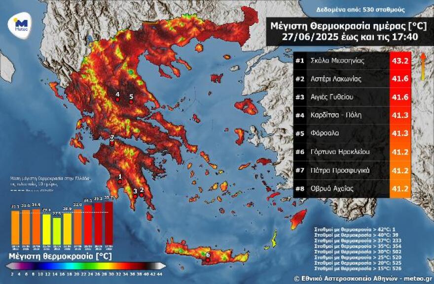
Figure 1. The distribution of the maximum temperature in the country according to the network of automatic meteorological stations of the National Observatory of Athens / meteo.gr.
The temperature also exceeded 40 °C in Athens and the surrounding areas. The highest maximum was recorded in Salamina (40.8 °C), followed by Vlychada (40.6 °C) and Harokopeio in Kallithea (40.5 °C). The map in Figure 2 shows the distribution of the maximum temperature on Friday 27/06 in Athens and the surrounding areas.
In the rest of the country generally clear weather with a few occasional clouds. Winds will blow from the north, in the west 4 to 5 and in the Aegean Sea 5 to 7 Beaufort.The temperature will drop by 2 to 3 degrees. It will reach 36 to 38 degrees Celsius on the mainland, 35 to 37 degrees Celsius on the Ionian Islands, the eastern Aegean, the Dodecanese and Crete, and 29 to 31 degrees Celsius in the Cyclades.
Analytical forecast:
ATTICA
Weather: generally clear. In the midday-afternoon hours a few clouds, partly cloudy with a possibility of local rain or isolated thunderstorms, mainly in the north.
Winds: From northern directions 4 to 5 and in the east locally 6 Beaufort.
Temperature: From 25 to 37 degrees Celsius.
From 25 to 25 degrees Celsius.
THESSALONIKI
Weather: showers and occasional thunderstorms that will quickly stop and the weather will become clear. Local clouds will develop again in the surrounding mountainous areas in the midday and afternoon hours where local rain is likely to occur.
Some clouds will develop again in the surrounding mountainous areas in the midday and afternoon hours where local rain is likely to occur.
Winds: Northwestern 4 to 6 Beaufort.Temperature: From 22 to 36 degrees Celsius.
Climate: 22° C to +22° C.
MAKEDONIA, THRACE
Weather. In the midday – afternoon hours, clouds will develop again with local rain and isolated thunderstorms, mainly in the mountains.
In the morning and afternoon hours, clouds will develop again with local rain and isolated thunderstorms, mainly in the mountains.
Winds: From northern directions 3 to 5 Beaufort.
From north to north-west, with winds from north-west and north-west winds from north-west to north-west.
Temperature: From 21 to 35 to 36 and locally 37 degrees Celsius. In Western Macedonia 2 to 3 degrees lower.
35 to 35 degrees Celsius and 35 to 35 degrees Celsius in the west.
Ionian Islands, Ionian Islands, HEPIROS, WEST MIDLAND, WEST PELOPONESOS
Weather. In the midday – afternoon hours on the mainland a few clouds, partly cloudy with local rain and occasional thunderstorms, mainly in western Sterea and western Peloponnese.
Winds: Northwestern 5 to 6 Beaufort.
Temperature: From 21 to 35 degrees Celsius, in the mainland locally 37 to 38 degrees Celsius.
From 21 to 35 degrees Celsius and from 21 to 35 degrees Fahrenheit.
ANATOLIKI STAREA, EUBOIA, ANATOLIKI PELOPONESOS
Weather. In the midday – afternoon hours on the mainland, a few clouds, partly cloudy with local rain and isolated thunderstorms, mainly in the mountains.
Winds: From northern directions 4 to 6 Beaufort 4 to 6 Beaufort.
From north to northwest, with winds from northwest to northwest.
Temperature: From 20 to 36 to 37 degrees Celsius.
From 20 to 30 degrees Celsius and from 20 to 30 degrees Fahrenheit.
CYCLADES, CRETE
Weather.
Winds: North-northwest 5 to 7 Beaufort.
Temperature: From 22 to 33 and in southern Crete locally up to 34 to 35 degrees Celsius.
From 22 to 35 degrees and from 22 to 35 degrees Celsius and from 22 to 35 degrees Celsius and from 22 to 35 degrees Fahrenheit.
ANATOLIKO AEGEAN ISLANDS – DODECANESE
Weather.
Winds: North-northwestern 5 to 6 Beaufort, and on the eastern Aegean islands 6 to 7 Beaufort.
Weather.
Northwestern Greece, northwestern Greece, north-eastern Greece, north-eastern Greece and north-eastern Greece.
Temperature: From 23 to 35 to 36 degrees Celsius.
From 23 to 35 degrees Celsius and from 23 to 35 degrees Fahrenheit.
THESSALYA
From 35 to 35 degrees Celsius.
Weather: generally clear. In the midday – afternoon hours a few clouds, partly cloudy with local rain and isolated thunderstorms on the mainland.
Winds: Northwestern 4 to 5 Beaufort, and in the sea 5 to 6 Beaufort.
Temperature: From 20 to 36 to 37 degrees Celsius.
From 20 to 30 degrees Celsius and from 20 to 30 degrees Fahrenheit.
In central and eastern Macedonia, Thrace, eastern Thessaly, the Sporades, eastern Sterea, Evia, eastern and southern Peloponnese, a few clouds, partly cloudy with local showers until the afternoon. In the rest of the country, generally clear weather.
The weather will be pleasant in all parts of the country.
Winds will blow from the north in the west 4 to 5, in the east 5 to 7, in the Aegean 7 to 8 and locally in the areas of Cyclades, Crete, Dodecanese and eastern Aegean islands up to 9 Beaufort.
The temperature will drop significantly and will not exceed 32 to 34 degrees.
Forecast for Monday, June 30
Generally clear weather with a few clouds in eastern Macedonia and Thrace and in the noon and afternoon hours in the northern continental mountains.
Winds will blow from the north from the west 3 to 5, in the east 4 to 6, in the Aegean Sea locally 7 and occasionally in the south up to 8 Beaufort.
The temperature will rise slightly in the east.
The weather will be mild in the south-eastern part of the country, with a slight breeze in the south-eastern part of the country, with a slight increase in the south-eastern part of the country.
Weather forecast for Tuesday, July 1
Generally clear weather with a few occasional clouds in the continental highlands in the midday and afternoon hours, when localised rain is likely in the north-east.
Winds will blow from the north in the west 3 to 5, in the east 4 to 6 and in the Aegean Sea locally 7 Beaufort.
The temperature will rise slightly further.
Weather forecast for Wednesday, July 2
Generally clear weather with a few occasional clouds in the midday and afternoon hours in the continental highlands, where localised rain is likely.
In the afternoon, there may be some chance of rain showers.
Winds will blow from northerly directions in the west 3 to 5, in the east 4 to 6 and in the Aegean Sea 7 and locally up to 8 Beaufort.
The temperature will not change significantly.
Ask me anything
Explore related questions


