Heat and humidity will prevail across the country today, while instability will once again make its appearance. From tomorrow, according to meteorologist Giorgos Tsatrafyllias of protothema.gr, instability will intensify, bringing strong storms, intense lightning activity, and possible hail. At the same time, temperatures will begin to gradually decline.
More specifically, today, Thursday, June 11, 2026, the weather will start with plenty of sunshine in most areas. However, from midday onwards, conditions will change over the mainland. Particularly in the Peloponnese, Central Greece, and Macedonia, local showers and thunderstorms are expected, mainly in mountainous and semi-mountainous areas.
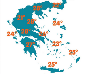
Maximum temperatures will reach 33–34°C in mainland Greece and 30–31°C in island regions.
Winds will blow from northwesterly directions in the Aegean, locally reaching up to 6 Beaufort, while in the Ionian Sea winds will generally be weak to moderate.
In Athens, the weather will be generally clear. Winds will be light, and temperatures will range between 20 and 33°C.
In Thessaloniki, a few brief showers are expected from midday onwards. Winds in the Thermaic Gulf will be light, while temperatures will reach up to 32°C.
Weather outlook for the coming days
On Friday (12/5), instability will increase in the mainland, especially in central and northern parts of the country. Strong rain and thunderstorms are expected, with intense lightning activity and a risk of local hail. Temperatures will also drop. These phenomena will also affect Athens during the warmest hours of the day.
On Saturday (13/5), rainfall will weaken and be limited mainly to the eastern and southern parts of the country, while on Sunday the phenomena will cease. Temperatures will drop further, and in most areas will not exceed 29–30°C. At the same time, the Meltemi winds in the Aegean will strengthen, reaching 6–7 Beaufort.
Ask me anything
Explore related questions


