The Bad Weather Has Begun Its Onslaught in Greece – Temperatures Plunge and Snow Appears in Mountainous Areas – The Next Two Days Will Be the Coldest with Further Drops in Temperature
According to weather forecasts, the bad weather will last until Tuesday (25/02). However, it is expected to peak on Friday, February 21, and Saturday, February 22, with a further drop in temperature, as stated by meteorologist Christina Rigou.
As reported by MEGA’s meteorologist, snow will fall at lower altitudes in Magnesia, Fthiotida, Attica, and Evia.
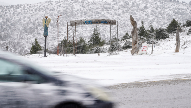
Where Snow Will Fall in Attica: In Attica, the heaviest snowfall is expected on Parnitha Mountain and surrounding areas, such as Ippokrateios Politeia, Kaphandriti, Varnavas, and Thrakomakedones, according to the meteorologist.
Additionally, snowflakes will fall in the northern suburbs, from Penteli to Dionysos and further north, with light snow accumulation expected.
Long-lasting Cold Invasion and Heavy Frost in the Coming Days
The Coral weather system has taken hold, bringing snow and a sharp drop in temperatures across parts of the country. Snow has already been reported in Evia and Parnitha, with the rest of the nation experiencing a biting cold. This cold spell is expected to persist through next Monday (24th February), making it a prolonged weather event.
Snow in Parnitha, Evia, and Lesvos
As of Wednesday morning (19th February), the villages of Steni, Metochi, Stropones, Glyfada, and Akres in Evia are blanketed in snow. Due to the weather, traffic on the Kymi-Metochi road is restricted, and vehicles can only pass with anti-slip chains.
On Thursday morning (20th February), heavy snow began falling in Parnitha, prompting local authorities to enforce traffic regulations to ensure safety. Snow and frost were also observed early this morning in Lesvos, particularly in the areas of Megali Limni, Achladeri, and Vasilika. To ensure road safety, the Region’s Project Machine has been activated to spread salt and maintain passability.
School Closures Across Affected Regions
Due to the severe weather, schools in several municipalities have been closed for two days. Specifically, Dirphi Messapia and Mantoudi Lake Agia Anna have suspended all classes, including kindergartens, primary, and secondary schools, for Thursday (20th February) and Friday (21st February).

Freezing Temperatures in the Coming Days
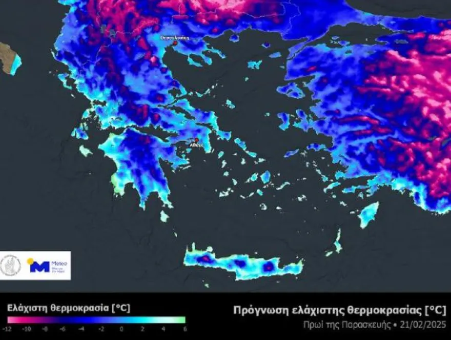
According to meteorological reports, temperatures are expected to stay well below freezing in the coming days. Early mornings in semi-mountainous and mountainous areas of central and northern Greece will see temperatures dipping below zero, with some places reaching -10°C.
An overview of the forecasted temperatures for Friday, 21st February shows chilly conditions throughout much of the country. Light and occasional snowfall will continue, particularly in Macedonia, Thessaly, Eastern Macedonia, Eastern Peloponnese, and Crete. Northerly winds in the Aegean will intensify, reaching 6-7 Beaufort at times.
Emergency Weather Bulletin by EMY
An emergency weather bulletin was issued on Thursday afternoon by EMY (Greek National Meteorological Service). According to the bulletin, the cold wave, named Coral, will persist across Greece and the wider southeastern Europe region until Monday, 24th February. The bulletin also warns of strong northerly winds of 7-8 Beaufort in places and localized snowfall in several regions, including the Aegean islands and Crete.
Detailed Forecast:
- Thursday (20th February): In Macedonia, Thrace, Thessaly, and parts of Eastern Peloponnese, temperatures will range between 6°C to 8°C, while in central and eastern Sterea, Euboea, and Peloponnese, temperatures may reach 8°C to 9°C. Snowfall is expected in central Macedonia, Thessaly, central and eastern Sterea, Euboea, and Crete.
- Friday (21st February): In Macedonia and Thrace, temperatures will dip to -7°C to 5°C, with snow expected in central Macedonia, Thessaly, central Sterea, Euboea, and parts of Crete.
- Saturday (22nd February): Cold conditions will continue, with temperatures dropping further in Macedonia and Thrace to around -5°C. Snowfall will occur in mountainous regions, with heavier snow possible in Crete and some Aegean islands.
A Look Ahead: Weather Outlook for Attica and Beyond
Yannis Kallianos, a prominent Greek meteorologist, predicts very low temperatures until Sunday, with frost especially intense in the mountains of Northern Greece. While snow will be more localized and lighter than in past storms, areas like Pieria, Thessaly, Fthiotida, and Evia could see heavier snowfall.
Attica will experience variable weather, with sporadic snowfalls in the northwest, north, and northeast of the region, particularly at altitudes of 150-200 meters. While snow is not expected to accumulate heavily in Athens, local snowfall could still cause disruptions in some areas.
Sunday, 23rd February could bring a recurrence of snow in northern parts of Greece, especially near Thessaloniki and Central Macedonia. However, this is still a developing situation that will be monitored closely.
What to Expect Over the Next Few Days
- Friday (21st February): Expect cloudy weather, with rain or sleet in Macedonia, Thessaly, Euboea, and Crete, and snowfall in mountainous and semi-mountainous regions.
- Saturday (22nd February): The weather will be cloudy with some light rain or sleet in the east, and snow in mountains across northern and eastern regions.
- Sunday (23rd February): The weather will remain cloudy with light rain or sleet, and snowfall in mountainous areas, especially in northern Greece and Crete.
Temperatures will remain chilly, with frost expected to persist, especially in the morning and evening hours.
Ask me anything
Explore related questions


